
Geographical Information System in City Gas
GIS is digitization and Mapping of underground and above ground infrastructure and equipment, establishment, route with depth and offset. It also includes technical attributes, maintenance schedule, inspection schedule, reminders in a City Gas Company for a meaningful analysis to take a decision with a user-friendly system.
GIS for City Gas companies is mandatory as per PNGRB Rules. It is a safety and early warning system for a CGD handling hazardous product that also in a populated City/geographical area.
Geography and its systematic information with IT is known as Geographical Information System.
City Gas Infrastructure
To reach each and every customer, City Gas companies are establishing/laying their networks. These networks are majorly of two kinds. One is above ground and another is underground.
Above ground infrastructure
City Gas stations as Gas terminals, Odoriser, CNG Stations, Pressure Regulating stations, Service regulators, dedicated PRS for industrial customers, above ground Sectionalising valve, Test Lead Points, RCC Markers, Route markers, Directional Markers, Transition fitting, Risers, GI for domestic connections, MS pipes for industrial and commercial connections are the mostly used above ground infrastructure. These can be seen.
Apart from these Gas meters, MRS and other measuring equipment likes Pressure gauges, filters and differential pressure gauges, regular equipment, safety equipment are also the integral part of above ground infra.
Underground infrastructure
Majorly pipelines, Carbon steel pipelines, Medium Density Polyethylene pipeline, underground steel and MDPE valve chambers, HDD and Moling sections are the underground infrastructure. Route diversions, off set, depth, pipe line integrity, maintenance, reminders for safe operations.
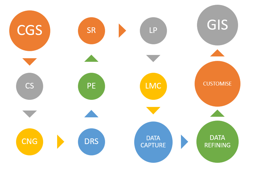
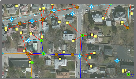
GIS System
Raw data
After execution of a project, construction and installation of equipment, keeping record of all actual data and information is really an uphill task. Either it is available in measurement books, pipe books, as-built drawing or in the memory of some key persons involved in.
For safe monitoring of underground and above ground infrastructure, it’s health, Operation & Maintenance, safety and compliance, records are not really available to help.
GIS is really helping at this point.
Data capturing
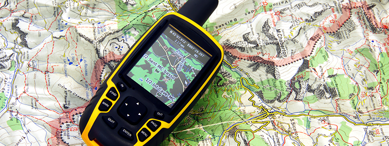
GIS is successful when correct data is available. Apart from availability of old data, CGD is expanding every year so that data is also important to capture. It is really important to capture data while execution. Real snap with coordinates and offset.
With the help of simple devices, real time data can be captured. Only required is one device with accurate GPS, camera, capturing few attributes. Collect and collate all raw data at a single point for refining.
Data refining & validation
Data received from site, MB and As Built need to crosschecked for its authenticity. With sample checking, it gets validated. Putting data or plotting on a platform is also explaining about the readiness to use.
Layers
GIS is a platform for various data levels. Data is required to plot layer wise so that at any level, data can be filtered for its proper use.
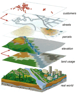
Layer-1
Underground steel pipe line network. As a main grid, layer one should be for steel pipelines network, depth, offset, elbow, joints, tines, HDD sections, moling sections, crossing sections, change in diameter through reducer or expander, isolation valves, various markers and TLPs.
Layer-2
Medium density polyethylene pipe line network, its connectivity, DRS gas injection points, Service regulators, isolation valve chambers, offset, depth, looping if any.
Layer-3
Above ground network like City Gate Stations, CNG Stations, PRS, Service regulators, control rooms and other which are being installed as a part of City Gas Network.
GIS Platform
Data and its various form are required to upload on a platform. These platforms can be any like Google based, ArcGIS, GE Small world or any other which is suitable for customisation, data layering, uploading and results.
These platforms are available with their various versions. Based on the requirement anyone can take for configuration.
It has been seen that smart engineers of City Gas Companies have made mini GIS type data system on their PC. Based on the data available or captured from site time to time, entered in Google earth free version for their personal information.
Even on any Smart phone, this kind of data can be captured and logged with small information for use at time to time for relevant purpose.
Information Technology
Any GIS platform and its data need to install and updated time to time with the help of IT. Normally, these data should install on cloud so that at any moment data can be accessed.
Based on relevance other SERVERs can also be used.
Application
As on date City Gas companies are adopting GIS just for compliance. But it has various advantages.Ready reckoner of assets.
Encyclopaedia for locational information.
Tracking of any encroachment near or over the infrastructure.
Safe upkeeping and maintenance of assets.
Equal distribution of area for responsible engineers for easy control.
Billing information for customers.
IMS integration.
Early warning system.
Road map for emergency handling.
Safe City Gas.
Drone technology

GIS provides a path and updated time to time based on the infrastructure laid/created. Advance technologies are available through which pipe line route can be tracked with drones. These drones can fly with permissions on route to check the changes on the route defined and on ground with imaging.
These need permission from local authorities.
Youre so right. Im there with you. Your weblog is surely worth a read if anyone comes throughout it. Im lucky I did because now Ive got a whole new view of this. I didnt realise that this issue was so important and so universal. You definitely put it in perspective for me.